The ANZAC Landings
I am here on a battlefield tour, and this post is going to be about the beginning of the Dardanelles land campaign. I’m writing it more to keep it straight in my head than anything else, so if you’re after whimsical anecdote you’ll have to wait for another day.
I do actually know a bit more about the campaign than the average punter. Rod, our ANZAC encyclopedia with the walrus moustache, tells us that the general Aussie on his tours knows that there was a landing at ANZAC cove, everything went very badly and it was all the fault of the British. And if you’re looking for it in a nutshell, well, there it is. But we’re not. Far from it. The whole thing lasted eight months and we’re here for five days, so there won’t be a full reenactment but we’ll certainly be hitting the highlights.
We started off with a ferry trip along the coast from Gaba Tepe, a little knoll sticking out into the sea, which at the time of the landings had a dug in little Turkish fortification in it.

We went close to the coast all the way up to Suvla Bay, where the British later landed to have a crack at salvaging the whole mess. The whole way along it is pretty clear that there wouldn’t be a worse place to land than ANZAC cove and the little beach to the north of it. The beach to the north of Gaba Tepe where they were supposed to land makes for a boring photo because it’s fairly featureless, quite long, and no cliffs rising straight up from the beach. But they were landed in the dark, towed out by teenaged midshipman kitted only with a compass, starting from a ship who had had to sneak out, also in the dark, from behind an island so whose position was also a bit uncertain. No wonder they got it wrong.
So this is where they did land.

Of course, there wasn’t a wall there then to keep the crumbling cliffs from falling into the sea, but you get the idea. It looked a lot smaller from the sea. No, this isn’t where they have the dawn services, that’s one beach up, and it’s even worse.

Although at least that had a little bit of shore to land on. Apparently ANZAC cove had a bit more beach a hundred years ago, but it has washed away. The feature sticking out in the above photo is The Sphinx, not the Egyptian one, but we were in such a small area of land for those eight months that every knob and gully in the landscape got a name.
Once they had landed they were to struggle up to as high ground as possible, and many of them managed to get up to a feature to the right of the Sphinx called Plugge’s Plateau. The idea was that once they were up there they were to cross to the next height, and this is the suggested route.

Unsurprisingly most of them chose to go down into the valley on the right of Razor’s Edge, and that’s where many of them spent the next eight months, in this valley, and up to the ridge, dug into trenches. It’s a really small area, and despite having read many excellent descriptions of the land and how difficult it was to fight in, you can’t quite believe it until you see it.

See, even a photo doesn’t do it justice, there’s quite a valley down there, and not a nice flat valley, one seamed with ridges and gullies, and most of it fairly exposed to Turkish fire until they’d dug themselves trenches to hide in. You can still see the remains of trenches, and I guess I’d always imagined them in straight lines.
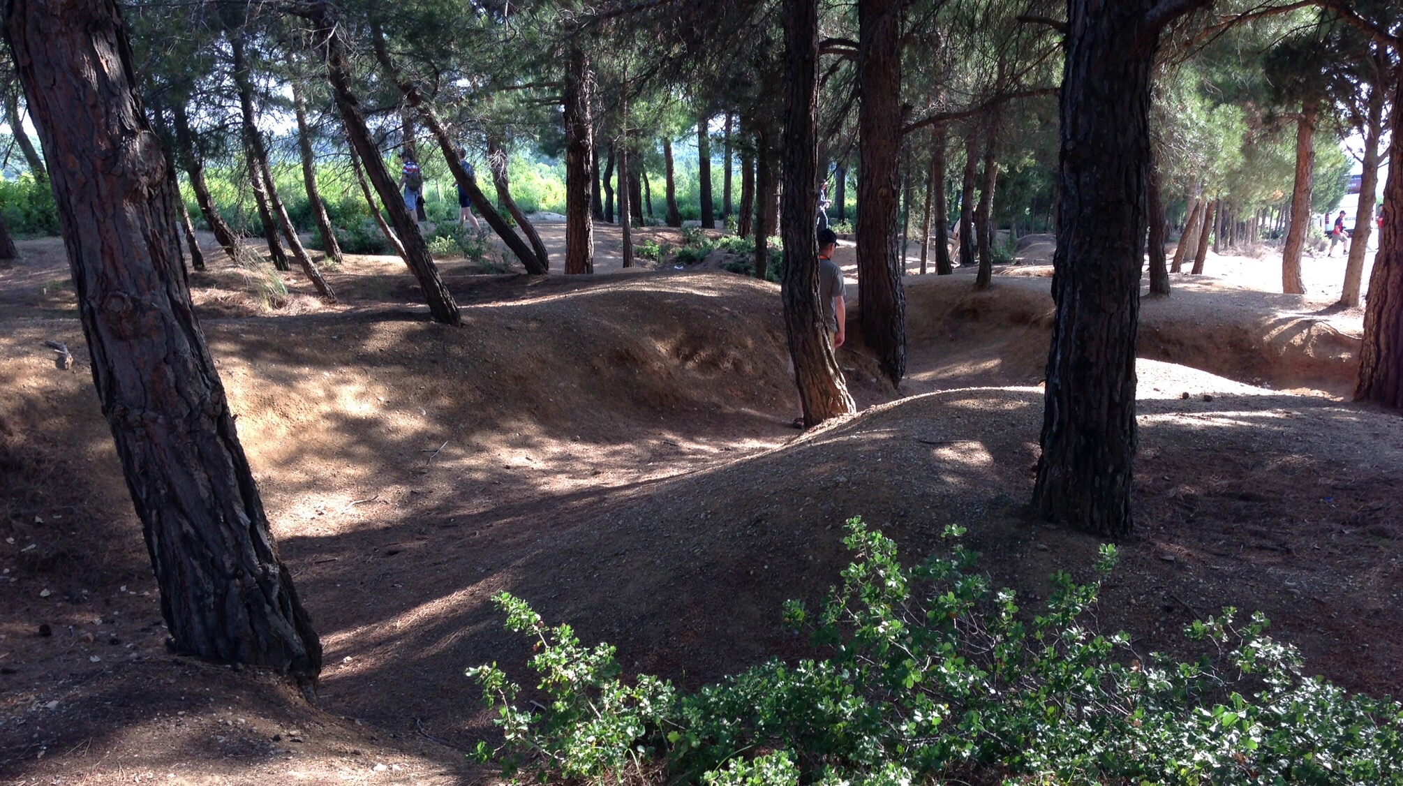
Obviously there weren’t any trees at all in the whole area, even the Lone Pine got blown to pieces fairly quickly. And these have had a century of erosion going on, but these are the real thing, untouched, unreconstructed, Australian trenches.
I can’t keep track of all of the battalions, platoons, regiments with their numbers and divisions that Rod can recite without notes, both Australian and Turkish. But the military guys are hanging on his every word, doing ground appreciations, suggesting alternative battle strategies, disputing who got the furthest inland. I can’t think of any other military engagement that so many Australians would know so very intimately.

